Problem
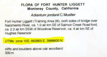
What if I see a bunch of numbers in a row followed by an E, then another set of numbers followed by an N. Then there's a zone. It looks something like the picture below. What is this and where should I put it?
Our Solution
UTM stands for Universal Transverse Mercator, and it is a system of assigning coordinates on the globe based on a specific projection (estimation of the flattened shape) of the Earth. In this system, the Earth is split up into 60 zones, and the "easting" and "northing" values provide the x and y coordinates of a specific location within that zone. More infomation about this coordinates system can be found here: https://en.wikipedia.org/wiki/Universal_Transverse_Mercator_coordinate_system
In CCH2, you can enter UTM coordinates as they are, and CCH2 will convert them into decimal latitude and longitude coordinates, our data standard. To do so, click the F button on the occurrence editor to open the formatting tools. A box in which you can enter coordinates is in the center (circled below). The number on the specimen label that followed by E should be put in the "East" field (don't type the E), and the number followed by N should be put in the "North" field (don't type the N). The zone will be a number between 1 and 60 (if the specimen is from California, it will be 10 or 11). Put this number in the "Zone" field, not including any extra letters. Once you have done this, click the Insert UTM Values button. If CCH2 is able to parse the values you have input, the Latitude and Longitude fields will be filled.
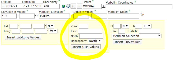
In the Georeference Sources field below these boxes, make sure to enter "UTMs on label" to document how these coordinates were created.