CALIFORNIA PHENOLOGY
  • Home
  • About
    • People >
      • Faculty & Staff
    • Phenological Research
    • Progress
    • Project Description
    • Project Plan
    • Related Projects
  • Get Involved!
    • 100 Club
    • CCH Meetings
    • Volunteers
  • Resources
    • Data Portal Tutorials >
      • CCH2 Survey Q&A
    • Digitization FAQ / Help page
    • Document Library
    • Equipment Recommendations
    • Funding Opportunities
    • Georeferencing >
      • Georeferencing in CCH2 Training Course
      • Georeferencing in CoGe Training Course
      • Georeferencing Protocols and Guides
      • Georeferencing Webinar
    • Phenological Scoring
    • Sensitive Taxa in CCH2
    • Workflow & Protocols
    • Webinars
  • Research
    • Presentations and Posters
    • Papers and Publications
  • Education
    • Educational Materials
    • Phenology Research Course
    • Media & News
    • Meetings & Upcoming Talks
  • Blog
  • Data Portal

CAP Georeferencing Protocols

Protocol for georeferencing individual specimen records ​(using the occurrence editor / data entry page in CCH2)
Download Protocol
Make sure to visit our Georeferencing Training Course for further training and demonstration of using this protocol.
​Batch georeferencing protocol ​(using the batch georeferencing tool)
Download Protocol
Protocol for Georeferencing in a CoGe community
Download Protocol

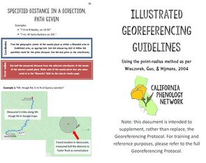
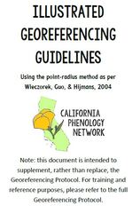
Illustrated Georeferencing Guide

Picture

Illustrated georeferencing guide
(booklet format, for printing)

Download Guide
Picture

Illustrated georeferencing guide
​(non-booklet format, for electronic use)

Download Guide

Georeferencing Webinar

This webinar describes the concept and process of georeferencing and focuses on demonstrating georeferencing tools in the CAP data portal, CCH2 (cch2.org). We provide examples of how to georeference certain localities, and when not to georeference.
Watch Webinar
Picture

Georeferencing Resources

Picture

CalTopo: Integrated USGS maps, aerial photos, and other layers to facilitate location discovery

Learn More
Picture

US Forest Service Interactive Map: Visualize forest service (FS) roads, campground, and trails

Learn More
Picture

USGS Historical Topographic Map Explorer

Learn More
Picture
Picture
Picture

Georeferencing.org: Conversion tools, maps, gazetteers, and more

USGS Topo Map Locator: free GeoPDFs of topo maps of historic and modern U.S.A.

Earth Point: Township Range Section Locator (Google Earth)

Learn More
Learn More
Learn More
Picture

Old Maps Online: Library of historical maps

Learn More
Picture

David Rumsey Historical Map Collection

Learn More
In particular, this State Highways of California, 1960 map is helpful:
Learn More
Picture

Perry Castaneda Library: Historical map collection

Learn More
  • Section Township Range Maps by Randy Majors

Other Georeferencing Guides & Protocols

Picture
Picture
Picture

Wieczorek et al. 2012. Georeferencing quick reference guide

Georeferencing herbarium specimens using GeoLocate   (iDigBio webinars)

Wieczorek et al. 2004: Original description of point-radius method of georeferencing

Learn More
Learn More
Learn More
Picture

Florida State University collaborative georeferencing protocol

Learn More
Picture

MSU Herbarium georeferencing protocol

Learn More
Picture

Florida Museum georeferencing protocol

Learn More
Picture
This project made possible by National Science Foundation Award 1802312.
Any opinions, findings, and conclusions or recommendations expressed in this material are those of the author(s) and do not necessarily reflect the views of the National Science Foundation.


Poppy images courtesy of Matt Ritter

Contact Us