Problem
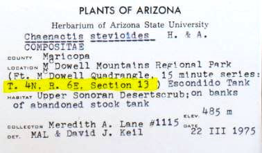
A label has T#N or T#S, R#W or R#E, and a section (sec.) value on it, like in the example below. What does this mean, and how do I enter this information in CCH2?
How do I georeference a specimen with TRS information?
How do I georeference a specimen with TRS information?
Our Solution
The letters and numbers you're seeing, like in the above example, are called township, range, and section coordinates, which are part of the U.S. Public Land Survey System, a system of defining locations that dates back to the 1700s. (Read more about it here: https://en.wikipedia.org/wiki/Public_Land_Survey_System)
The T value is the "township", which designates a 6-mile by 6-mile squares. The R value is the "range", which measures the distance east or west of the meridian. The section or "sec." is a numbered square within the township, measuring 1-mile by 1-mile.
In CCH2, you can enter TRS coordinates as they are, and you can convert them into a latitude, longitude, and error radius using GeoLocate. To do so, click the F button on the occurrence editor to open the formatting tools. A box in which you can enter TRS data is on the right (circled below).
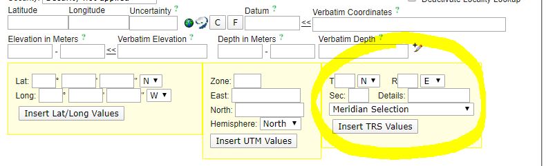
The number following the T should be entered in the first box. Then select either N or S from the adjacent dropdown menu. Then enter the number following the R in the second box and select either E or W from the adjacent dropdown menu. Last, enter the section or "sec." number in the Sec field. If more than one section is listed, enter them both in the Details field. If other information, such as "NW 1/4 of SE 1/4" are also listed with the TRS data, enter this information in the Details field. Then click the Insert TRS Values button.
Georeferencing using TRS values:
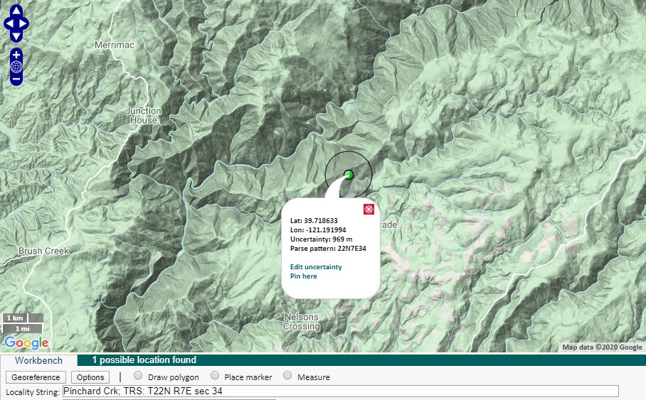
If you come upon a specimen that has TRS data while you are georeferencing, first try to find the approximate lat/longs from the TRS data provided. First, enter the TRS data as described above and click the Insert TRS Values button. Then click the GeoLocate button (to the right of the latitude/longitude/uncertainty fields). If GeoLocate was able to use the TRS data provided, the resulting coordinates will have an uncertainty (error radius) of 969 meters, and the parse pattern will match the TRS data you input. In the example below, the TRS data we entered were "T22N R7E Section 34".
If no additional locality data are provided, you can just use the latitude, longitude, and uncertainty provided by GeoLocate from the TRS data. However, pay close attention to whether you can be more specific than the TRS coordinates. Often, more information about the precise location of the specimen is provided, which can allow you to more accurately place the point and more precisely estimate the uncertainty of the location. Use the georeferencing protocol to determine whether you can georeference the point more precisely than just using the TRS data. Once you have finished georeferencing, as always, click the Save to Your Application button and save your work in the occurrence editor.