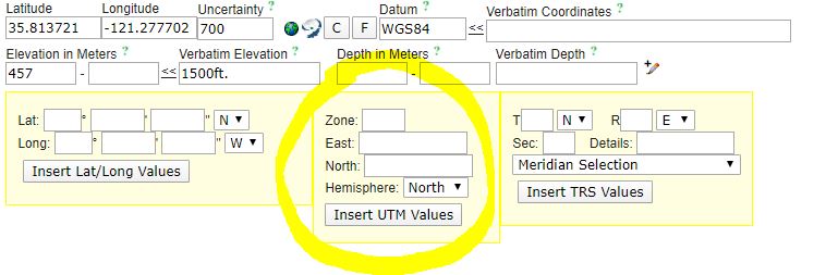
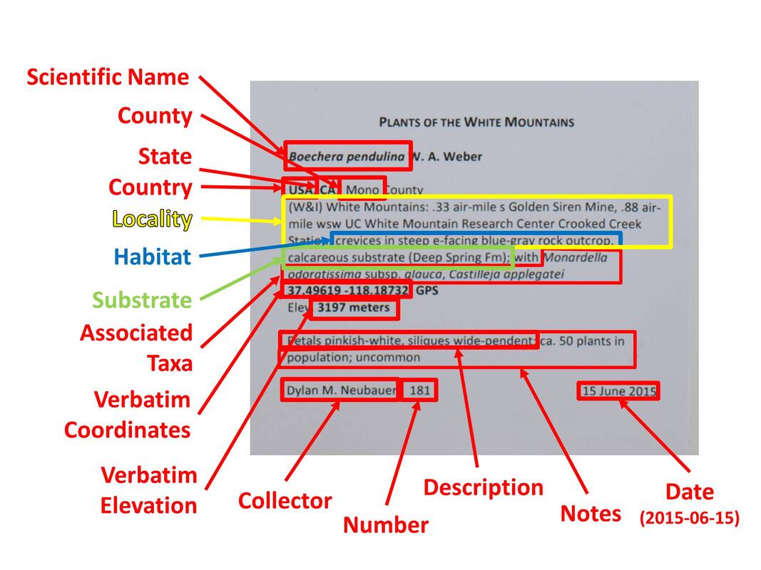
CALIFORNIA PHENOLOGY
  • Home
  • About
    • People >
      • Faculty & Staff
    • Phenological Research
    • Progress
    • Project Description
    • Project Plan
    • Related Projects
  • Get Involved!
    • 100 Club
    • CCH Meetings
    • Volunteers
  • Resources
    • Data Portal Tutorials >
      • CCH2 Survey Q&A
    • Digitization FAQ / Help page
    • Document Library
    • Equipment Recommendations
    • Expert Identification
    • Funding Opportunities
    • Georeferencing >
      • Georeferencing in CCH2 Training Course
      • Georeferencing in CoGe Training Course
      • Georeferencing Protocols and Guides
      • Georeferencing Webinar
    • Phenological Scoring
    • Sensitive Taxa in CCH2
    • Workflow & Protocols
    • Webinars
  • Research
    • Presentations and Posters
    • Papers and Publications
  • Education
    • Educational Materials
    • Phenology Research Course
    • Media & News
    • Meetings & Upcoming Talks
  • Blog
  • Data Portal

Does Mexico have counties, and what is a "municipio"?

5/11/2020

0 Comments

 
Problem
  • A specimen collected in Mexico does not have a "county"
  • A specimen collected in Mexico has a "municipio" on the label or the abbreviated form "mun."
Our Solution
Mexico is divided into administrative sections called "states", and these states are further divided into "municipios", sometimes abbreviated "mun." When transcribing a specimen from Mexico, that state (Spanish: estado) should be entered in the State or Province field, and the municipio should be entered into the County field.
0 Comments

What do T, R, and sec. mean on a label?

5/5/2020

1 Comment

 
Problem
A label has T#N or T#S, R#W or R#E, and a section (sec.) value on it, like in the example below. What does this mean, and how do I enter this information in CCH2?
​How do I georeference a specimen with TRS information?
Picture
Our Solution
The letters and numbers you're seeing, like in the above example, are called township, range, and section coordinates, which are part of the ​U.S. Public Land Survey System, a system of defining locations that dates back to the 1700s. (Read more about it here: https://en.wikipedia.org/wiki/Public_Land_Survey_System)
The T value is the "township", which designates a 6-mile by 6-mile squares. The R value is the "range", which measures the distance east or west of the meridian. The section or "sec." is a numbered square within the township, measuring 1-mile by 1-mile.
In CCH2, you can enter TRS coordinates as they are, and you can convert them into a latitude, longitude, and error radius using GeoLocate. To do so, click the F button on the occurrence editor to open the formatting tools. A box in which you can enter TRS data is on the right (circled below).
Picture
The number following the T should be entered in the first box. Then select either N or S from the adjacent dropdown menu. Then enter the number following the R in the second box and select either E or W from the adjacent dropdown menu. Last, enter the section or "sec." number in the Sec field. If more than one section is listed, enter them both in the Details field. If other information, such as "NW 1/4 of SE 1/4" are also listed with the TRS data, enter this information in the Details field. Then click the Insert TRS Values button.
Georeferencing using TRS values:
If you come upon a specimen that has TRS data while you are georeferencing, first try to find the approximate lat/longs from the TRS data provided. First, enter the TRS data as described above and click the Insert TRS Values button. Then click the GeoLocate button (to the right of the latitude/longitude/uncertainty fields). If GeoLocate was able to use the TRS data provided, the resulting coordinates will have an uncertainty (error radius) of 969 meters, and the parse pattern will match the TRS data you input. In the example below, the TRS data we entered were "T22N R7E Section 34".
Picture
If no additional locality data are provided, you can just use the latitude, longitude, and uncertainty provided by GeoLocate from the TRS data. However, pay close attention to whether you can be more specific than the TRS coordinates. Often, more information about the precise location of the specimen is provided, which can allow you to more accurately place the point and more precisely estimate the uncertainty of the location. Use the georeferencing protocol to determine whether you can georeference the point more precisely than just using the TRS data. Once you have finished georeferencing, as always, click the Save to Your Application button and save your work in the occurrence editor.
1 Comment

What are UTMs?

5/5/2020

1 Comment

 
Problem
What if I see a bunch of numbers in a row followed by an E, then another set of numbers followed by an N. Then there's a zone. It looks something like the picture below. What is this and where should I put it?
Picture
Our Solution
UTM stands for Universal Transverse Mercator, and it is a system of assigning coordinates on the globe based on a specific projection (estimation of the flattened shape) of the Earth. In this system, the Earth is split up into 60 zones, and the "easting" and "northing" values provide the x and y coordinates of a specific location within that zone. More infomation about this coordinates system can be found here: https://en.wikipedia.org/wiki/Universal_Transverse_Mercator_coordinate_system
In CCH2, you can enter UTM coordinates as they are, and CCH2 will convert them into decimal latitude and longitude coordinates, our data standard. To do so, click the F button on the occurrence editor to open the formatting tools. A box in which you can enter coordinates is in the center (circled below). The number on the specimen label that followed by E should be put in the "East" field (don't type the E), and the number followed by N should be put in the "North" field (don't type the N). The zone will be a number between 1 and 60 (if the specimen is from California, it will be 10 or 11). Put this number in the "Zone" field, not including any extra letters. Once you have done this, click the Insert UTM Values button. If CCH2 is able to parse the values you have input, the Latitude and Longitude fields will be filled.
Picture
In the Georeference Sources field below these boxes, make sure to enter "UTMs on label" to document how these coordinates were created.
1 Comment

Where can I find useful historical and present-day maps of California?

4/30/2020

0 Comments

 
Take a look at the USGS's archive of topo maps: https://store.usgs.gov/map-locator. Most PDFs are completely free, and you can even search for maps of specific quadrangles.
0 Comments

The label says "sea level". What does that tell me about elevation?

4/28/2020

0 Comments

 
​Problem
The label includes "sea level", but does not list another elevation.
Our Solution
You can assume 0 meters for the elevation at sea level. Enter 0 for the minimum elevation in meters and enter "sea level" (without quotation marks) in the verbatim elevation field.
0 Comments

Should I enter information on label headers?

4/28/2020

1 Comment

 
​Problem
The label has a header. Should I enter this information somewhere?
Our Solution
You should only enter header information in the data entry form if it indicates that the plant was collected for a very special project, such as "Plants of Irrigation Canals". Do not include the full header if it only indicates the flora or a survey of a specific region, for example, "Plants of Joshua Tree National Park" or "Flora of Riverside County." For the first example, you would put just "Joshua Tree National Park" in the Locality field (as long as you aren't duplicating information that is listed elsewhere on the label). For the second example, you would select Riverside as the county, but nowhere do you need to indicate "Flora of Riverside County" verbatim.
You also do not need to enter header information if it indicates the name of an herbarium or specific collection. Be aware that the name of the collector is sometimes included in the name of the herbarium, but only rarely.
1 Comment

Where do I put the notes that are displayed on the annotation label?

4/28/2020

0 Comments

 
Problem
Information other than the identifier, date, and species identification is included on the annotation label.
Our Solution
You can enter any extra information on the annotation label in the ID Remarks field. This field can be found once you click the pencil icon in the Latest Identification box.
If the information is just the name of an herbarium or university (i.e., the affiliation of the determiner), do not transcribe this information.
0 Comments

What does "det." or "determiner" mean and where do I transcribe it?

4/28/2020

0 Comments

 
Problem
The label has "det.", "determiner", "determined by", or "confirmed by" somewhere on the label.
Our Solution
The determiner is the person who identified the plant. This person is not always the same as the plant collector. The name after "det.", "determiner", "determined by", or "confirmed by" (i.e., person who confirmed the identification) should be entered into the Identified By field in the Latest Identification box.
0 Comments

Where should I put information about the plant's frequency?

4/28/2020

0 Comments

 
Problem
Words that describe the frequency of the plant species are included, such as common, uncommon, rare, frequent, infrequent, locally common, not seen elsewhere.
Our Solution
This information goes in the Notes (Occurrence remarks) field because it describes the species rather than the plant on the specimen.
0 Comments

Chromosome count or other information about the specimen provided that doesn't seem to fit in any other field

4/28/2020

0 Comments

 
Problem
Information that doesn't seem to fit in any other field is provided, such as:
  • Chromosome count (2n = xx)
  • Sheet # of #
  • "Collected as part of a survey..."
  • Information about the collector's permit or project
Our Solution
All of the above information should be entered in the Notes (Occurrence remarks) page.
0 Comments

Common names

4/28/2020

0 Comments

 
​Problem
There is a common name listed on the label.
​Our solution
You do not need to transcribe (type) the common name from the label. If you are instructed to do so by your supervisor, enter it in the Taxon Remarks field. This field is found by clicking the pencil icon in the bottom left corner of Latest Identification box.
0 Comments

How can I tell what should go in the "locality" versus the "habitat" field?

4/28/2020

2 Comments

 
​Problem
Habitat and locality/location terms are mixed together, even within the same sentence.
Our Solution (adapted from the Notes from Nature blog)
  • Often, general/non-specific locales are Habitat, and specific ones are Locality, since a species is very rarely found in only one place where the specimen was obtained.
    • For example, “along road” would be Habitat because it describes the environment the plant grows in, but “along Smith Road” would be Locality as it describes the specific road where this specimen was found. However, you can also add "along road" to the habitat information, because it describes the type of environment in which the plant was found.
    • For “Bank of Smith River”, “bank of river” would be put into Habitat and “Bank of Smith River” would be put in Locality.
  • Separate phrases by semicolons or periods, as long as it does not change the meaning of the text.
  • Drop unnecessary dangling non-terminal punctuation as needed. For example, “Dry roadside, east of Smithville” would result in “Dry roadside” Habitat, dropping the dangling comma as it is doesn’t terminate a sentence properly.
  • Data that goes into Habitat:
    • Floodplain describes a habitat. This often occurs with a river name, so for “Mississippi River floodplain”, include of the text in the Habitat field. Since in this case it wouldn’t be accurate to just have “Mississippi River” in the locality field.
    • Power lines: as they may help narrow a location but say more about the habitat in which the plant grows as power line corridors are usually cleared of larger shrubs and trees.
  • Data that goes into Locality:
    • Directions to get to a location or the human-given name of that location. For example, towns, roads, mountain ranges, distances, directions, or other descriptive information should go in the Locality field.
Below are a few examples of labels parsed out into Habitat and Locality fields.
Picture
Picture
Picture
Picture
2 Comments

What do I do if the county isn't specified on the label?

4/28/2020

0 Comments

 
Problem
The specimen was collected in the U.S. but a county is not specified on the label.
Our Solution
First, look again! Sometimes the county is "hidden" in the header text or somewhere else on the label where you might not immediately see it. For example, if the label header says "Plants of San Luis Obispo County" or "Flora of Fresno County", you can assume that the plant was collected in San Luis Obispo.
​If you still can't find the county on the label, you can search online for the appropriate county using the locality information provided on the label. If there are multiple potential counties for a locality and you can't determine which one is correct, leave the County field blank.
0 Comments

What should I do when there is a special character like a degree symbol or language-specific character?

4/28/2020

1 Comment

 
Problem
There is a symbol or other language-specific character in text of a label. Such as °, ±, ≥, ♂, ♀, ⅛ ¼ ⅓ ⅜ ½ ⅝ ⅔ ¾ ⅞, Ä, ä, Á, á, å, Å, ð, ë, ğ, Ñ, ñ, õ, Ö, ö, Ó, ó, Ü, ü, Ž, or ž.
Our Solution
Copy and paste that symbol from an online source (or this blog post) or from a word processor (e.g., Pages, Word) on your computer. There are some keyboard shortcuts for entering common symbols (the plus signs mean you should hold down the keys together):
Windows
  • ° = Alt+248
  • ñ = Alt+0241
  • ± = Alt+0177
  • é = Alt+130
Mac
  • ° = Shift+Options+8
  • ñ = Options+n, then hit n again
  • ± = Options+Shift+=
  • é = Options+e, then hit e again
1 Comment

What are all these words and symbols in the scientific name?

4/23/2020

1 Comment

 
Problem
The scientific name is followed by (or contains) abbreviations, punctuation, and words that don't look like parts of a scientific name. For example: L. , Gray, (Nutt.) Ottley, Ruiz & Pav. , Jeps. ...and so many more!
Our Solution
The basic botanical name consists of three parts: the genus, specific epithet, and species authorship. The genus and specific epithet together designate the species of the plant, and the authorship indicates the original author of that scientific name (for example, "L." refers to Carl Linnaeus, a botanist from the 1700s who named thousands of the species we recognize today).
Picture
You should only enter the genus and specific epithet in the Scientific Name field. The authorship will (ideally) auto-populate when you press Tab or move to another field.
​This can get a little tricky when the scientific name includes an infraspecific epithet (like a var. or subsp.; see this blog post).
Picture
In these cases, you still only enter the genus, specific epithet, infraspecific rank (the var. or subsp.) and the infraspecific epithet, all in bold above. Fortunately, you should be able to select the correct name from the dropdown menu, which will make it clear which parts of the name you should enter.
1 Comment

What do var. , ssp. , subsp. , forma, and f. mean?

4/23/2020

1 Comment

 
Problem
The scientific name contains, among other things, "var.", "ssp", "subsp.", "forma", or "f.".
Our Solution
The first of these abbreviations denote a specific variety (var.) or subspecies (subsp. or ssp.) of the species. These are taxon ranks that are more specific than species. For example, they may indicate a few populations within the species that share some common characteristics that make them distinct, but not necessarily a  different species. Varieties and subspecies should be included in the Scientific Name field, and use "subsp." instead of "ssp." for consistency, even when the label says "ssp." You should not include the author names in your entry (see this post for more about author names). For example, "Echinodorus cordifolius (Linnaeus) Grisebach ssp. cordifolius" should be transcribed as "Echinodorus cordifolius subsp. cordifolius".
A forma (sometimes abbreviated f.) is a secondary taxon rank, even below variety. It denotes a special form (e.g., a different color) of that species or variety. Formae are not generally included in our taxonomic thesaurus, so if this information is present but you cannot find it in the dropdown list, enter the forma into the ID remarks field instead of the Scientific Name field (click the pencil icon at the bottom of the Latest Identification box; see below). The rest of the scientific name (before the forma) can be entered in the Scientific Name field.
Picture
1 Comment

What if the specimen is cultivated, but it was originally collected from a different place?

4/23/2020

0 Comments

 
Problem
A specimen is noted as cultivated at one location, but it originated (i.e., from seed, a cutting, a rhizome) from another location, as in the specimen below.
Picture
Our Solution
Enter the name of the place where the specimen was cultivated into the Locality field. The Country, State/Province, and County should also reflect the place where the specimen was cultivated. Enter the place where the seed/cutting/rhizome was collected in the Notes (Occurrence remarks) field. For the habitat field, enter "cultivated". Any habitat information about the seed/cutting/rhizome collection should be included in the Notes (Occurrence remarks) field.
​Note: it can be tricky to determine whether the specimen itself is a sample from the wild individual or from the cultivated specimen. For example, the label below represents a plant that was in the wild, and cuttings of it are now in a botanic garden. In this case, the locality and habitat fields should be populated according to the information provided on the label, not the location of the botanic garden.
Picture
0 Comments

Collection date is a range, incomplete, cut off, or vague

4/23/2020

0 Comments

 
Problem
  • The collection date is a range, such as 27-29 July 1974
  • The collection date is cut off, incomplete, or unclear, such as July 4
  • The collection date is vague, such as Spring 1955
Our Solution
Enter as much data as you have, in standard year-month-date format (YYYY-MM-DD), into the date field. Any information that you do not have from the label, you should replace with zeros. For date ranges, provide only the level of detail above the date range. You should then type exactly what the label says into the Verbatim Date field. Examples of each of these special cases are shown below. 
If the date appears to be cut off because the specimen was imaged incorrectly, change the processing status of the specimen record to Expert Required and write "needs to be re-imaged because date is cut off" in the Data Generalizations field.
What the label says
What you should enter in the Date field
June 1945
1945-06-00
July 4
(leave blank and fill in Verbatim Date)
January 15th, 198
​(leave blank and fill in Verbatim Date)
Spring 1955
​1955-00-00
​September 17-23, 1989
​1989-09-00
​June - August 1805
​1805-00-00
0 Comments

Multiple collectors, potentially some with the same last name

4/23/2020

2 Comments

 
Problems
  • How do you enter multiple collectors on the label, and how do you determine who the primary collector is?
  • When the collectors are listed together with the same last name, how do you enter them?
  • What do you do when a collector has Dr., Mrs., Mr., etc. in front of their name.
Our Solutions
When multiple collectors are listed on a label, put the person who seems to be the primary collector in the Collector field and the remainder of the collectors in the Associated Collectors field. Separate the associated collectors by semicolons, and do not include words like "and" or "with" or symbols such as ampersands (&).
Sometimes it can be challenging to determine who the primary collector is, and you may have to get familiar with a particular collector's label style before you recognize that collector as the primary collection. Sometimes the collector will put a letter in front of the collector number that will help you identify who the primary collector is. For example, in the label below, we can see that Elinor Lehto indicated that she is the primary collector by putting an L in front of the collection number.
Picture
When two collectors have the same last name and are written together (e.g., "R. & M Spellenberg"), write each name out individually with their last name (e.g., "R. Spellenberg; M. Spellenberg).
Transcribe the collector names as shown on the label, including honorifics (e.g., Mrs., Dr.).
2 Comments

What do I do if the annotation label does not have the whole scientific name spelled out?

4/23/2020

0 Comments

 
Problem
The scientific name on an annotation label or determination label just as a single letter followed by a specific epithet (the species name is not completely written out).
Picture
Our Solution
If the first letter is the same as the previous annotation, it is safe to assume the same genus is being used. For example, you would enter the scientific name of the annotation above as Dryopteris intermedia since the initial determination was Dryopteris. If the first letter is not the same, you may have to do a little research to determine what that first letter might indicate. Also make sure to check the rest of the specimen to see if there was an annotation label that you missed. When all else fails, change the processing status of the record to Expert Required and describe the problem in the Data Generalizations field.
0 Comments

What should I do if part of the label is in all caps?

4/22/2020

0 Comments

 
Problem
All or part of the label is in all caps, such as CALIFORNIA or SAN BERNARDINO MTNS.
Our solution
In the case of over-exuberant capitalization (all capital letters), you should capitalize only the first letter of every word in your transcription unless the all caps are an abbreviation. For example, "TRANSVERSE RANGES" should be transcribed as "Transverse Ranges".
0 Comments

What do I do if I find a mispelling?

4/22/2020

0 Comments

 
Problem
What should I enter if I find a mispelling or a spelling mistake?
Our solution
Transcribe exactly as written, unless you have looked it up and are absolutely certain of a simple spelling mistake. In this case, you can enter the correct spelling.
0 Comments

What do I do if the label isn't in English?

4/22/2020

0 Comments

 
Problem
A label or information on the label is provided in a foreign language other than English, such as Spanish, German, French, or Latin.
Our Solution
When you find non-English labels, transcribe these exactly as written; do not translate to English. Match label content to transcription fields as best as you can. If you happen to speak or understand the language presented on the label, you can provide a translation in square brackets [ ]. For example, if you find "flores de color lila claro" on the label, you can type it as: "flores de color lila claro [light purple flowers]".
0 Comments

What is a nearest named place?

4/22/2020

0 Comments

 
Problem
​When georeferencing, the protocol says that the size of the error radius depends on the location of the nearest named place. What is a named place in this context?
​Our Solution
A named place is a bounded or unbounded geographical area that has a designated name, such as a town, mountain, river, or body of water. You will need to use your best judgment to determine what is a "nearest named place" to use when designating an error radius. For example, if your locality information is vague (e.g., "Mount Shasta"), your error radius should be pretty large to account for that vagueness. In this example, your "nearest named place" should not be a lodge or town that is halfway down one side of Mount Shasta.
0 Comments

Should I shorten or abbreviate longer organization or place names? Should I spell out abbreviations?

4/22/2020

0 Comments

 
​Question
When transcribing, can I use acronyms or otherwise shorten the names of common or well-known places? For example, if the label says "California Polytechnic University," can I just transcribe "Cal Poly"?
Conversely, when an acronym is provided (e.g., JTNP instead of Joshua Tree National Park), should I spell out the acronym?
​Our Solution
Unless otherwise instructed by your supervisor, you should enter location information exactly as it appears on the label. Yes, that means you should transcribe "National Park" instead of "Natl Park" or "NP" if it is fully spelled out on the label.
Similarly, if an abbreviation or acronym is provided on the label and you think you know what it is, you should still transcribe the information exactly as it appears on the label. However, you can add your interpretation of that abbreviation in block quotes [ ]. For example: "JTNP [Joshua Tree National Park]".
0 Comments

    Welcome to our Digitization FAQ and Help Page!

    To find the answer to your question, try searching these pages (Cmd or Ctrl + F) for pertinent keywords relating to your problem or question.

    Can't find the answer you're looking for? Email our project manager, Katie Pearson
Picture
This project made possible by National Science Foundation Award 1802312.
Any opinions, findings, and conclusions or recommendations expressed in this material are those of the author(s) and do not necessarily reflect the views of the National Science Foundation.


Poppy images courtesy of Matt Ritter

Contact Us